Be Better, Be Stronger
个人简介
社会服务
| 2023- | 中国测绘学会大数据与人工智能工作委员会 | 委员 |
| 2023- | 中国地理信息产业协会政务信息工作委员会 | 委员 |
| 2023- | Journal of Spatial Science (SCI, IF:1.9) | 编委 |
| 2022- | Frontiers in Remote Sensing | 副主编 |
| 2024-2025 | IEEE JSTARS (SCI, IF:4.7) | 客座编辑, Special Issue:"Challenges and Recent Progress in Remote Sensing of Nighttime Light" |
| 2022-2023 | Land (SSCI, IF:3.398) | 客座编辑, Special Issue "Future Urban Land Expansion in China" |
| 2021-2023 | Remote Sensing (SCI, IF:4.848) | 客座编辑, Special Issue:"Recent Advances of Urban Development Scenarios Simulation Using Remote Sensing and GIS" |
| 2019-2020 | IEEE JSTARS (SCI, IF:3.392) | 客座编辑, Special Issue:"Advances in Remote Sensing of Nighttime Lights: Progresses, Challenges, and Perspectives" |
| 2015- | IEEE TGRS、RSE、遥感学报等国内外顶级期刊 | 审稿人(详见:Publons) |
研究方向
| 以夜间灯光遥感数据处理、分析、应用为主的城市遥感 |
科研奖励
| 2024.12 | 福州大学“旗山学者”奖励计划 |
| 2024.11 | 福建省自然科学基金优青项目 |
| 2023.7 | 福建省高层次人才(C类) |
科研项目
9. 主持福建省自然科学基金优青项目,2024-2027
8. 主持重点研发项目子课题,2023-2026
7. 主持2023年度《地球大数据支撑可持续发展目标报告》研究案例培育项目,2022-2023
6. 主持2022年度《地球大数据支撑可持续发展目标报告》研究案例培育项目,2021-2022
5. 主持/参与多地“十四五”数字建设专项规划,2021-2022
4. 主持中国博士后科学基金面上项目,2020-2022
3. 主持国家自然科学基金青年科学基金项目,2019-2021
2. 主持武汉大学测绘遥感信息工程国家重点实验室珞珈一号特别开放基金,2018-2019
1. 主持中国博士后科学基金面上项目,2018-2020
研究成果
代表性成果
城市内部空间结构识别
夜光景观指数
(ESI前1%高被引论文)
基于CUDA并行的太阳辐射估算
基于色温的夜间光源分类体系(UAV)
城市住房空置率估算
期刊论文(7篇ESI前1%高被引论文,1篇ESI前0.1%热点论文)
#:共同一作co-first authors,*:通讯作者corresponding author
2025年
[90] Wang Congxiao, Chen Zuoqi, Wu Bin, Zhang Hong, Gu Honghuan, Tu Yue, Li Wei, Yuan Yuan, Yu Bailang*, 2025, Border identification and spatial evolution of metropolitan areas by surface network analysis using nighttime light data. Information Geography. 100018.
[89] Wang Congxiao, Xu Wei, Chen Zuoqi, Liu Shaoyang, Li Wei, Zhang Lingxian, Gao Shimin, Huang Yan, Wu Jianping, Yu Bailang*, 2025, STARS: A novel gap-filling method for SDGSAT-1 nighttime light imagery using spatiotemporal and spectral synergy. Remote Sensing of Environment 322, 114720.
[88] Zou Chenru, Chen Zuoqi*, Yu Bailang, Zheng Qiming, Wang Congxiao, 2025, An object-oriented nighttime light classification based on light color temperature: A new perspective from AAV nighttime images. IEEE Transactions on Geoscience and Remote Sensing, 63, 1–13.
[87] Xu Zhibang*, Xu Gang, Ting Lan, Li Xi, Chen Zuoqi, Cui Hao, Zhou Zhengzi, Wang Haowei*, Jiao Limin*, Christopher Small, 2025, Global consistency of urban scaling evidenced by remote sensing. PNAS Nexus, 4: pgaf037.
2024年(共16篇)
[86] 陈佐旗*, 苏瑞浩, 2024, 基于夜光景观指数的灾区经济变化特征及其城乡差异研究. 亚热带资源与环境学报, 19(04): 136–146.
[85] Chen Zuoqi, You Xiaojun, Wang Congxiao, Wu Wenting, Wei Ye, Shi Kaifang, Yu Bailang*, 2024, An increasing mutual promotion of economic growth between China and the world observed from nighttime light remote sensing, International Journal of Digital Earth, 17(1): 2426521.
[84] 刘少阳, 陈佐旗, 施开放, 吴宾, 魏冶, 王丛笑, 黎夏, 吴健平, 余柏蒗*, 2024, 夜间灯光遥感揭示21世纪以来中国西北部地区城市化演化格局与过程. 遥感学报 28(6): 1497–1514.
[83] Li Yangguang, Wu Bin, Wang Congxiao*, Chen Zuoqi, Liu Shaoyang, Yu Bailang, 2024, Measuring human settlement wealth index at 10-km resolution in low- and middle-income countries from 2005 to 2020 using multi-source remote sensing data. International Journal of Digital Earth 17(1): 2353160.
[82] Liu Shaoyang, Wang Congxiao, Wu Bin, Chen Zuoqi, Zhang Jiarui, Huang Yan, Wu Jianping, Yu Bailang*, 2024, Integrating NTL Intensity and Building Volume to Improve the Built-Up Areas’ Extraction from SDGSAT-1 GLI Data. Remote Sensing, 16(13): 2278.
[81] 华婧, 吴宾, 陈佐旗, 杨成术, 唐曦, 孙斐然, 吴健平, 余柏蒗*, 2024, 精准扶贫背景下中国贫困县的夜间灯光时空变化分析. 遥感学报, 28(4): 940-955.
[80] Tu Yue, Wang Congxiao*, Yu Bailang, Chen Zuoqi, Zhang Tinglin, 2024, What is the Nighttime Light Interaction Index? Validations at Yangtze River Delta Urban Agglomerations. IEEE Geoscience and Remote Sensing Letters, 21,1-5.
[79] Wu Wenting*, Lin Zhibin, Chen Chunpeng, Chen Zuoqi, Zhao Zhiyuan, Su Hua, 2024, Tracking the dynamics of tidal wetlands with time-series satellite images in the Yangtze River Estuary, China. International Journal of Digital Earth, 17, 2330684
[78] 张婧薇, 陈佐旗, 苏华*, 2024, 基于广义相加模型的东南沿海叶绿素a浓度的多重影响与季节差异. 遥感技术与应用, 39, 134-148
[77] Jia Mingming*, Zeng Haihang, Chen Zuoqi, Wang Zongming, Ren Chunying, Mao Dehua, Zhao Chuanpeng, Zhang Rong, Wang Yeqiao, 2024, Nighttime light in China's coastal zone: The type classification approach using SDGSAT-1 Glimmer Imager. Remote Sensing of Environment, 305, 114104 (ESI高被引)
[76] Liu Shaoyang, Wang Congxiao, Chen Zuoqi, Li Wei, Zhang Lingxian, Wu Bin, Huang Yan, Li Yangguang, Ni Jingwen, Wu Jianping, Yu Bailang*, 2024, Efficacy of the SDGSAT-1 glimmer imagery in measuring sustainable development goal indicators 7.1.1, 11.5.2, and target 7.3. Remote Sensing of Environment, 305, 114079
[75] Pan Zhan, Wang Congxiao, Yu Bailang*, Chen Zuoqi, Yuan Yuan, Li Guorong, Zhang Jiarui, Xiao Tian, 2024. Assessing multifunctional retrofit potential of urban roof areas and evaluating the power and carbon benefits under efficient retrofit scenarios. Journal of Cleaner Production, 141270
[74] Chen Zuoqi*, Xu Wenxiang, Zhao Zhiyuan, 2024. The Assessment of Industrial Agglomeration in China Based on NPP-VIIRS Nighttime Light Imagery and POI Data. Remote Sensing, 16, 417
[73] Li Daichao, Xu Fangnian, Chen Zuoqi*, Xie Xiaowei, Fan Kunkun, Zeng Zhan, 2024. Fine simulation of PM2.5 combined with NPP-VIIRS night light remote sensing and mobile monitoring data. Science of the Total Environment, 914, 169955
[72] Liu Shaoyang, Wang Congxiao*, Chen Zuoqi, Li Qiaoxuan, Wu Qiusheng, Li Yangguang, Wu Jianping, Yu Bailang*, 2024. Enhancing nighttime light remote Sensing: Introducing the nighttime light background value (NLBV) for urban applications. International Journal of Applied Earth Observation and Geoinformation, 126, 103626
[71] Wang Congxiao, Chen Zuoqi, Yu Bailang*, Wu Bin, Wei Ye, Yuan Yuan, Liu Shaoyang, Tu Yue, Li Yangguang, Wu, Jianping, 2024, Impacts of COVID-19 on urban networks: Evidence from a novel approach of flow measurement based on nighttime light data. Computers, Environment and Urban Systems, 107, 102056
2023年(共6篇)
[70] Shi Kaifang, Ma Jinji, Chen Zuoqi, Cui Yuanzheng*, Yu Bailang*, 2023. Nighttime light remote sensing in characterizing urban spatial structure. The Innovation Geoscience, 100043
[69] Chen Zuoqi*, Li Qianyu, Su Hua, 2023, Do the urban polycentricity and dispersion affect multisectoral carbon dioxide emissions? A case study of 95 cities in southeast China based on nighttime light data. International Journal of Digital Earth, 16, 4867-4884
[68] Yuan Yuan, Wang Congxiao, Liu Shaoyang, Chen Zuoqi, Ma Xiaolong, Li Wwei, Zhang Lingxian, Yu Bailang*, 2023, The Changes in Nighttime Lights Caused by the Turkey-Syria Earthquake Using NOAA-20 VIIRS Day/Night Band Data. Remote Sensing, 15, 3438
[67] Yuan Yongxin, Chen Zuoqi*, 2023, The impacts of land cover spatial combination on nighttime light intensity in 2010 and 2020: a case study of Fuzhou, China. Computational Urban Science, 3(1): 5
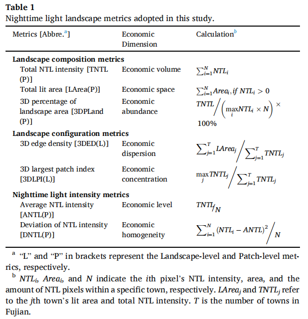
[66] Chen Zuoqi, Yu Siyi, You Xiaojun, Yang Chengshu, Wang Congxiao, Lin Juan, Wu Wenting, Yu Bailang*, 2023, New nighttime light landscape metrics for analyzing urban-rural differentiation in economic development at township: A case study of Fujian province, China. Applied Geography 150: 102841(ESI高被引)
[65] Shi Kaifang, Wu Yizhen, Liu Shirao, Chen Zuoqi, Huang Chang, Cui Yuanzheng, 2023, Mapping and evaluating global urban entities (2000–2020): A novel perspective to delineate urban entities based on consistent nighttime light data. GIScience & Remote Sensing, 60, 2161199(ESI高被引)
2022年(共13篇)
[64] Wu Wenting, Zhi Chao, Chen Chunpeng, Tian Bo, Chen Zuoqi, Su Hua, 2022, Detecting annual anthropogenic encroachment on intertidal vegetation using full Landsat time-series in Fujian, China. GIScience & Remote Sensing, 59, 2266-2282
[63] Wu Jihao, Tu Yue, Chen Zuoqi*, Yu Bailang, 2022, Analyzing the Spatially Heterogeneous Relationships between Nighttime Light Intensity and Human Activities across Chongqing, China, Remote Sensing 14(22): 5695
[62] SONO Douglas, Wei Ye, Chen Zuoqi, Jin Ying, 2022, Spatiotemporal Evolution of West Africa’s Urban Landscape Characteristics Applying Harmonized DMSP-OLS and NPP-VIIRS Nighttime Light (NTL) Data. Chinese Geographical Science, 32(6): 933-945
[61] Qiu Bingwen, Lin Duoduo, Chen Chongcheng, Yang Peng, Tang Zhenghong, Jin Zhenong, Ye Zhiyan, Zhu Xiaolin, Duan Mingjie, Huang Hongyu, Zhao Zhiyuan, Xu Weiming, Chen Zuoqi, 2022, From cropland to cropped field: A robust algorithm for national-scale mapping by fusing time series of Sentinel-1 and Sentinel-2. International Journal of Applied Earth Observation and Geoinformation 113: 103006
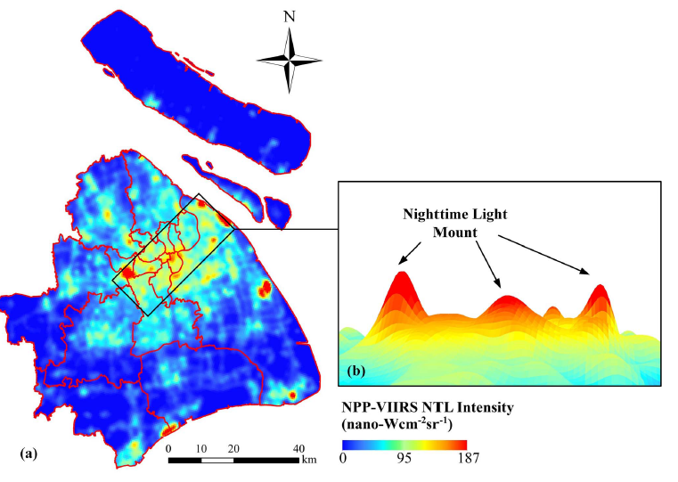
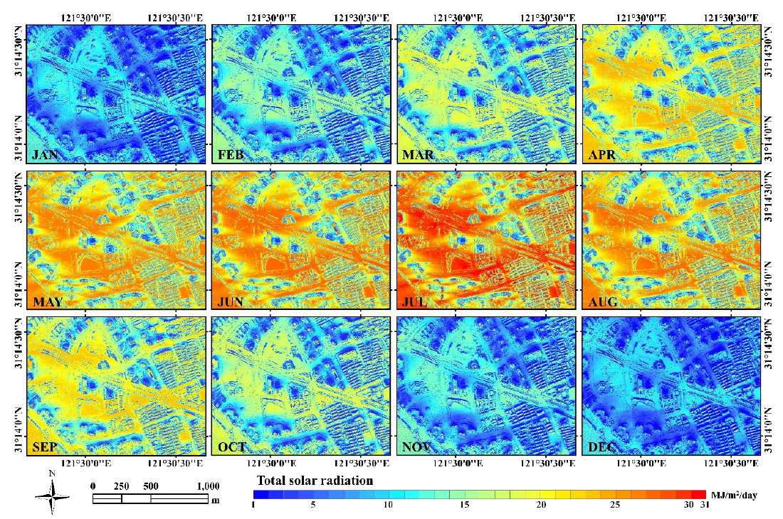
[60] Chen Zuoqi, Yu Bailang, Li Yong, Wu Qiusheng, Wu Bin, Huang Yan, Wu Siyuan, Yu Siyi, Mao Weiqing, Zhao Feng, Wu Jianping, 2022, Assessing the potential and utilization of solar energy at the building-scale in Shanghai. Sustainable Cities and Society, 82, 103917
[59] Qiu Bingwen, Ye Zhiyan, Chen Chongcheng, Tang Zhenghong, Chen Zuoqi, Huang Hongyu, Zhao Zhiyuan, Xu Weiming, Joe Berry, 2022, Dense canopies browning overshadowed by global greening dominant in sparse canopies. Science of The Total Environment, 826: 154222.
[58] You Xiaojun, Chen Zuoqi*, 2022, Interaction and mediation effects of economic growth and innovation performance on carbon emissions: Insights from 282 Chinese cities. Science of the Total Environment, 831, 154910
[57] Wu Yizhen, Shi Kaifang*, Chen Zuoqi, 2022, Developing Improved Time-Series DMSP-OLS-Like Data (1992-2019) in China by Integrating DMSP-OLS and SNPP-VIIRS. IEEE Transactions on Geoscience and Remote Sensing, 60: 1-14.
[56] You Xiaojun, Kyle Monahan, Yang Wenlong*, Wei Suqiong, Chen Zuoqi, 2022, How long do we wait to innovate? understanding causal relationships between economic and innovation performance with temporal lags: evidence from a dynamic panel of 282 cities in China. Technology Analysis & Strategic Management, 1-15
[55] Chen Zuoqi, Wei Ye, Shi Kaifang, Zhao Zhiyuan, Wang Congxiao, Wu Bin, Qiu Bingwen, Yu Bailang, 2022, The potential of nighttime light remote sensing data to evaluate the development of digital economy: A case study of China at the city level. Computers, Environment and Urban Systems, 92, 101749
[54] Tu Yue, Chen Zuoqi*, Wang Congxiao, Yu Bailang, Liu Bingjie, 2022, Quantitative Analysis of Urban Polycentric Interaction using Nighttime Light Data: A Case Study of Shanghai, China. IEEE Journal of Selected Topics in Applied Earth Observations and Remote Sensing
[53] Wu Wenting, Zhi Chao, Gao Yiwei, Chen Chunpeng, Chen Zuoqi, Su Hua, Lu Wenfang, Tian Bo, 2022, Increasing fragmentation and squeezing of coastal wetlands: Status, drivers, and sustainable protection from the perspective of remote sensing. Science of the Total Environment, 811, 152339
[52] Wu Bin, Yang Chengshu, Chen Zuoqi, Wu Qiusheng, Yu Siyi, Wang Congxiao, Li Qiaoxuan, Wu Jianping, Yu Bailang, 2022, The relationship between urban 2D/3D landscape pattern and nighttime light intensity. IEEE Journal of Selected Topics in Applied Earth Observations and Remote Sensing, 1-1
2021年(共9篇)
[51] 刘冰洁, 陈佐旗*, 余柏蒗, 杨成术, 邱炳文, 涂越, 2021, 夜间灯光遥感对城市发展类动能与相似性评估. 遥感学报, 25, 1187-1200
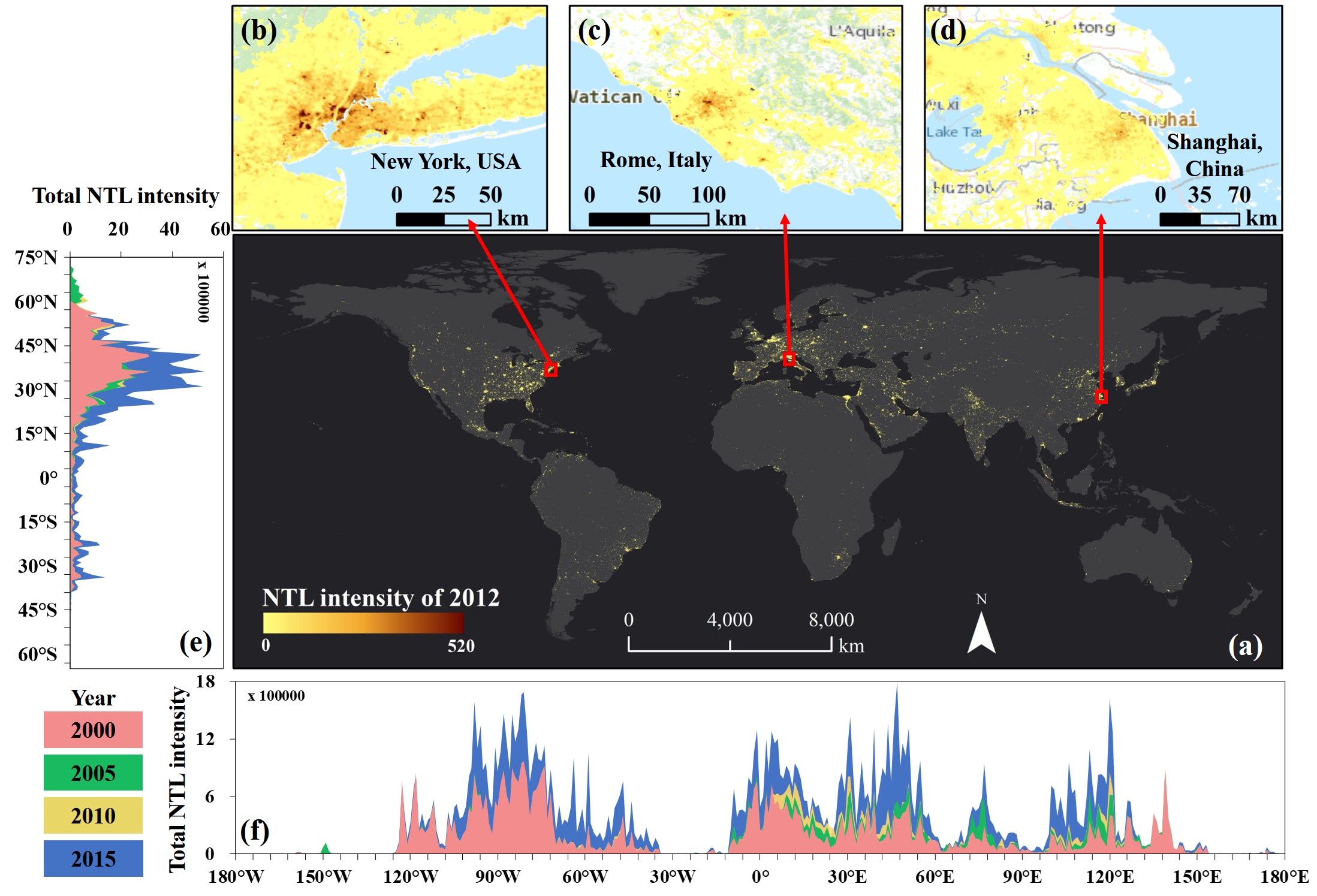
[50] Chen Zuoqi, Yu Bailang*, Yang Chengshu, Zhou Yuyu, Yao Shenjun, Qian Xingjian, Wang Congxiao, Wu Bin, Wu Jianping, 2021, An Extended Time Series (2000–2018) of Global NPP-VIIRS-like Nighttime Light Data from a Cross-sensor Calibration. Earth System Science Data, 13, 889-906 (ESI高被引&热点)
[49] Hong Yuchen, Wu Bin, Song Zhichao, Li Yangguang, Wu Qiusheng, Chen Zuoqi, Liu Shaoyang, Yang Chengshu, Wu Jianping, Yu Bailang, 2021, A monthly night-time light composite dataset of NOAA-20 in China: a multi-scale comparison with S-NPP. International Journal of Remote Sensing, 42, 7931-7951
[48] Wang Congxiao, Yu Bailang, Chen Zuoqi, Liu Yan, Song Wei, Li Xia, Yang Chengshu, Small Christopher, Shu Song, Wu Jianping, 2021, Evolution of Urban Spatial Clusters in China: A Graph-Based Method Using Nighttime Light Data, Annals of the American Association of Geographers, 1-22
[47] 张雪霞, 吴升, 赵志远, 王鹏洲, 陈佐旗, 方志祥, 2021, 基于手机信令数据的城市小活动空间人群空间分布特征. 地球信息科学学报, 23, 1433-1445
[46] Chen Hongxing, Wu Bin, Yu Bailang*, Chen Zuoqi, Wu Qiusheng, Lian Ting, Wang Congxiao, Li Qiaoxuan, Wu Jianping, 2021, A New Method for Building-Level Population Estimation by Integrating LiDAR, Nighttime Light, and POI Data. Journal of Remote Sensing, 2021, 9803796
[45] Su Hua, Lu Xuemei, Chen Zuoqi, Zhang Hongsheng, Lu Wenfang, Wu Wenting, 2021, Estimating Coastal Chlorophyll-A Concentration from Time-Series OLCI Data Based on Machine Learning. Remote Sensing, 13, 576
[44] Ding Yu, Chen Zuoqi, Lu Wenfang, Wang Xiaoqin, 2021, A CatBoost approach with wavelet decomposition to improve satellite-derived high-resolution PM2.5 estimates in Beijing-Tianjin-Hebei. Atmospheric Environment, 249, 118212
[43] 余柏蒗,王丛笑,宫文康,陈佐旗,施开放,吴宾,洪宇辰,李乔玄,吴健平, 2021. 夜间灯光遥感与城市问题研究:数据、方法、应用和展望. 遥感学报, 25, 342-364
2020年(共9篇)
[42] Shi Kaifang, Chen Zuoqi, Cui Yuanzheng, Wu Jianping, Yu Bailang, 2020, NPP-VIIRS Nighttime Light Data Have Different Correlated Relationships With Fossil Fuel Combustion Carbon Emissions From Different Sectors. IEEE Geoscience and Remote Sensing Letters, 1-5. (doi: 10.1109/LGRS.2020.3014956)(SCI)
[41] 陈芳鑫, 邱炳文, 陈佐旗, 何玉花, 黄莹泽, 李宇, 2020, 玉米种植面积对“镰刀弯”政策响应的时空差异与启示. 中国农业资源与区划, 41, 85-92
[40] Wu Bin, Wu Siyuan, Li Yong, Wu Jianping, Huang Yan, Chen Zuoqi, and Yu Bailang*, 2020, Automatic building rooftop extraction using a digital surface model derived from aerial stereo images. Journal of Spatial Science, 1-20. (DOI: 10.1080/14498596.2020.1720836)(SCI)
[39] 周亚娟,赵志远,吴升,方志祥,陈佐旗, 2020, 基于大规模手机位置数据的城市潜在自行车出行需求评估.地球信息科学学报,22(06):1282-1293.
[38] Yu Siyi, Chen Zuoqi, Yu Bailang*, Wang Lei, Wu Bin, Wu Jianping, Zhao Feng, 2020, Exploring the relationship between 2D/3D landscape pattern and land surface temperature based on explainable eXtreme Gradient Boosting tree: A case study of Shanghai, China. Science of The Total Environment, 725: 138229. (DOI: 10.1016/j.scitotenv.2020.138229)(SCI)
[37] Wu Bin, Wu Siyuan, Li Yong, Wu Jianping, Huang Yan, Chen Zuoqi, Yu Bailang*, 2020, Automatic building rooftop extraction using a digital surface model derived from aerial stereo images. Journal of Spatial Science, 1-20. (DOI:10.1080/14498596.2020.1720836)(SCI)
[36] Cheng Bin#, Chen Zuoqi#, Yu Bailang*, Li Qiaoxuan, Wang Congxiao, Li Beibei, Wu Bin, Li Yong, Wu Jianping, 2020, Automated Extraction of Street Lights From JL1-3B Nighttime Light Data and Assessment of Their Solar Energy Potential. IEEE Journal of Selected Topics in Applied Earth Observations and Remote Sensing, 13, 675-684. (DOI: 10.1109/JSTARS.2020.2971266) (SCI)
[35] Shi Kaifang, Xu Tao, Li Yuanqing, Chen Zuoqi, Gong Wenkang, Wu Jianping, Yu Bailang*, 2020, Effects of urban forms on CO2 emissions in China from a multi-perspective analysis, Journal of Environmental Management, 262: 110300. (DOI: 10.1016/j.jenvman.2020.110300) (SCI)
[34] Shi Kaifang, Chang Zhijian, Chen Zuoqi, Wu Jianping, Yu Bailang*, 2020, Identifying and evaluating poverty using multisource remote sensing and point of interest (POI) data: A case study of Chongqing, China, Journal of Cleaner Production. 255, 120245 (DOI: 10.1016/j.jclepro.2020.120245) (SCI)
2019年(共10篇)
[33] Zhao Xizhi, Yu Bailang, Liu Yan, Chen Zuoqi, Li Qiaoxuan, Wang Congxiao, Wu Jianping, 2019, Estimation of Poverty Using Random Forest Regression with Multi-Source Data: A Case Study in Bangladesh. Remote Sensing, 11(4): 375.
[32] Wang Congxiao, Chen Zuoqi, Yang Chengshu, Li Qiaoxuan, Wu Jianping, Zhang Guo*, Yu Bailang*, 2019, Analyzing the parcel-level relationship between Luojia 1-01 nighttime light intensity and artificial surface features across Shanghai, China: A comparison with NPP-VIIRS data, International Journal of Applied Earth Observation and Geoinformation. 85, 101989. (DOI: 10.1016/j.jag.2019.101989) (SCI)
[31] Yang Chengshu, Yu Bailang*, Chen Zuoqi, Song Wei, Zhou Yuyu, Li Xia, Wu Jianping, 2019, A Spatial-Socioeconomic Urban Development Status Curve from NPP-VIIRS Nighttime Light Data, Remote Sensing. 11(20), 2398. (DOI: 10.3390/rs11202398) (SCI)
[30] Wei Ye, Chen Zuoqi*, Xiu Chunliang, Yu Bailang, Liu Hongxing, 2019, Siting of Dark Sky Reserves in China Based on Multi-source Spatial Data and Multiple Criteria Evaluation Method. Chinese Geographical Science. (DOI:10.1007/s11769-019-1079-2) (SCI)
[29] Liang Handong, Guo Zhongyang, Wu Jianping, Chen Zuoqi*, 2019, GDP spatialization in Ningbo City based on NPP/VIIRS night-time light and auxiliary data using random forest regression. Advances in Space Research. (DOI:10.1016/j.asr.2019.09.035) (SCI)
[28] Chen Zuoqi, Yu Bailang, Ta Na, Shi Kaifang, Yang Chengshu, Wang Congxiao, Zhao Xizhi, Deng Shunqiang, Wu Jianping, 2019, Delineating Seasonal Relationships Between Suomi NPP-VIIRS Nighttime Light and Human Activity Across Shanghai, China. IEEE Journal of Selected Topics in Applied Earth Observations and Remote Sensing, 1-9. (10.1109/JSTARS.2019.2916323)(SCI)
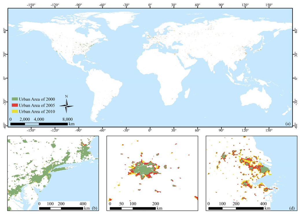
[27] Chen Zuoqi, Yu Bailang, Zhou Yuyu, Liu Hongxing, Yang Chengshu, Shi Kaifang, Wu Jianping, 2019, Mapping global urban areas from 2000 to 2012 using time series nighttime light data, IEEE Journal of Selected Topics in Applied Earth Observations and Remote Sensing. (DOI: 10.1109/JSTARS.2019.2900457) (SCI, Cover Paper)
[26] Wu Bin, Yu Bailang, Yao Shenjun, Wu Qiusheng, Chen Zuoqi, Wu Jianping, 2019. A surface network based method for studying urban hierarchies by night time light remote sensing data. International Journal of Geographical Information Science, 33, 1377-1398. (DOI: 10.1080/13658816.2019.1585540) (SCI/SSCI)
[25] Shi Kaifang, Yang Qingyuan, Fang Guangliang, Yu Bailang, Chen Zuoqi, Yang Chengshu, Wu Jianping, 2019, Evaluating spatiotemporal patterns of urban electricity consumption within different spatial boundaries: A case study of Chongqing, China. Energy, 167: 641-653. (DOI: 10.1016/j.energy.2018.11.022)
[24] Shi Kaifang, Yu Bailang, Zhou Yuyu, Chen Yun, Yang Chengshu, Chen Zuoqi, Wu Jianping, 2019, Spatiotemporal variations of CO2 emissions and their impact factors in China: A comparative analysis between the provincial and prefectural levels. Applied Energy, 233-234: 170-181. (DOI: 10.1016/j.apenergy.2018.10.050) (SCI)
2018年(共5篇)
[23] Yu Bailang, Tang Min, Wu Qiusheng, Yang Chengshu, Deng Shunqiang, Shi Kaifang, Peng Chen, Wu Jianping, Chen Zuoqi*, 2018, Urban Built-Up Area Extraction From Log-Transformed NPP-VIIRS Nighttime Light Composite Data. IEEE Geoscience and Remote Sensing Letters. 18(5), 1279-1283. (DOI: 10.1109/lgrs.2018.2830797) (SCI)
[22] Yu Bailang, Lian Ting, Huang Yan, Yao Shenjun, Ye Xinyue, Chen Zuoqi, Yang Chengshu, Wu Jianping, 2018. Integration of nighttime light remote sensing images and taxi GPS tracking data for population surface enhancement. International Journal of Geographical Information Science, 33, 687-706(SCI)
[21] Zhao Xizhi, Yu Bailang*, Liu Yan*, Yao Shenjun, Lian Ting, Chen Liujia, Yang Chengshu, Chen Zuoqi, Wu Jianping, 2018, NPP-VIIRS DNB Daily Data in Natural Disaster Assessment: Evidence from Selected Case Studies, Remote Sensing (Accepted) (SCI)
[20] Yu Bailang, Deng Shunqiang, Liu Gang, Yang Chengshu, Chen Zuoqi, Hill Catherine, Wu Jianping, 2018, Nighttime light images reveal spatial-temporal dynamics of global anthropogenic resources accumulation above ground, Environmental Science & Technology (Accepted) (SCI)
[19] Wu Bin, Yu Bailang*, Wu Qiusheng, Chen Zuoqi, Yao Shenjun, Huang Yan, Wu Jianping*, 2018, An Extended Minimum Spanning Tree Method for Characterizing Local Urban Patterns. International Journal of Geographical Information Science. 32(3): 450-475. (DOI: 10.1080/13658816.2017.1384830) (SCI)
2017年之前
[18] Chen Zuoqi, Yu Bailang*, Song Wei, Liu Hongxing, Wu Qiusheng, Shi Kaifang, Wu Jianping*, 2017, A New Approach for Detecting Urban Centers and Their Spatial Structure with Nighttime Light Remote Sensing. IEEE Transactions on Geoscience and Remote Sensing. 55, 6305-6319. (DOI: 10.1109/TGRS.2017.2725917) (SCI).
[17] Wu Qiusheng, Deng Chengbin, and Chen Zuoqi, 2016, Automated Delineation of Karst Sinkholes from Lidar-Derived Digital Elevation Models, Geomorphology,266, 1-10. (DOI: 10.1016/j.geomorph.2016.05.006) (SCI)
[16] Wu Qiusheng, Su Haibin, Douglas J Sherman, Liu Hongxing, Jennifer M Wozencraft, Yu Bailang, and Chen Zuoqi, 2016, A Graph-Based Approach for Assessing Storm-Induced Coastal Changes, International Journal of Remote Sensing, 37, 4854-73. (DOI: 10.1080/01431161.2016.1225180) (SCI)
[15] Wu Bin, Yu Bailang, Wu Qiusheng, Huang Yan, Chen Zuoqi, and Wu Jianping, 2016, Individual Tree Crown Delineation Using Localized Contour Tree Method and Airborne Lidar Data in Coniferous Forests, International Journal of Applied Earth Observation and Geoinformation, 52, 82-94. (DOI: 10.1016/j.jag.2016.06.003) (SCI)
[14] Shi Kaifang, Chen Yun, Yu Bailang, Xu Tingba, Yang Chengshu, Li Linyi, Huang Chang, Chen Zuoqi, Liu Rui, and Wu Jianping, 2016, Detecting Spatiotemporal Dynamics of Global Electric Power Consumption Using DMSP-OLS Nighttime Stable Light Data, Applied Energy, 184, 450-63. (DOI: 10.1016/j.apenergy.2016.10.032) (SCI)
[13] Shi Kaifang, Chen Yun, Yu Bailang, Xu Tingbao, Li Liny, Huang Chan, Liu Rui, Chen Zuoqi, and Wu Jianping, 2016, Urban Expansion and Agricultural Land Loss in China: A Multiscale Perspective, Sustainability, 8(8), 790. (DOI: 10.3390/su8080790) (SCI & SSCI)
[12] Shi Kaifang, Chen Yun, Yu Bailang* Xu Tingbao, Chen Zuoqi, Liu Rui, Li Linyi, Wu Jianping, 2016 Modeling spatiotemporal CO2 (carbon dioxide) emission dynamics in China from DMSP-OLS nighttime stable light data using panel data analysis. Applied Energy. 168: 528-533. (DOI: 10.1016/j.apenergy.2015.11.055) (SCI)
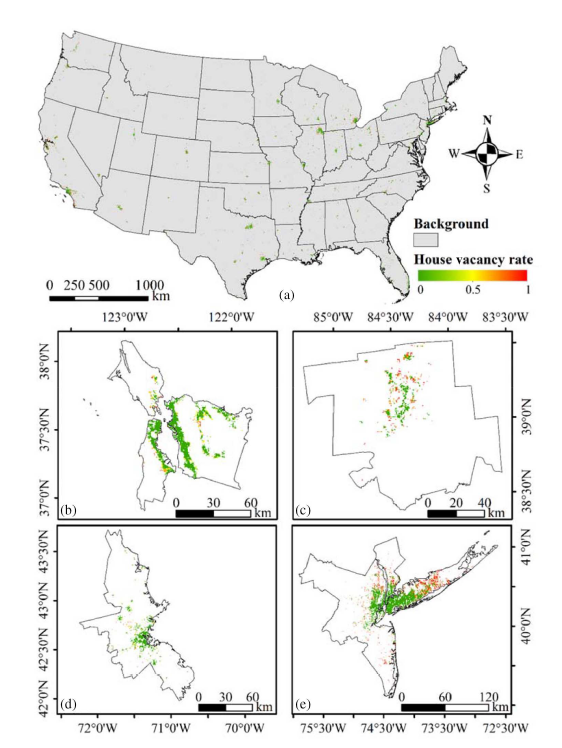
[11] Chen Zuoqi, Yu Bailang*, Hu Yingjie, Huang Chang, Shi Kaifang, Wu Jianping, 2015, Estimating House Vacancy Rate in Metropolitan Areas using NPP-VIIRS Nighttime Light Composite Data. IEEE Journal of Selected Topics in Applied Earth Observations and Remote Sensing. 8(5): 2188-2197. (DOI: 10.1109/JSTARS.2015.2418201) (SCI)
[10] Huang Yan, Chen Zuoqi, Wu Bin, Chen Liang, Mao Weiqing, Zhao Feng, Wu Jianping, Wu Junhan, Yu Bailang*, 2015 Estimating roof solar energy potential in the downtown area using a GPU-accelerated solar radiation model and airborne LiDAR data. Remote Sensing. 7(12): 17212-17233. (DOI: 10.3390/rs71215877) (SCI)
[9] Shi Kaifang, Yu Bailang*, Hu Yingjie, Huang Chang, Chen Yun, Huang Yixiu, Chen Zuoqi, Wu Jianping, 2015, Modelling and mapping total freight traffic in China using NPP-VIIRS nighttime light composite data. GIScience and Remote Sensing. 52(3): 274-289. (DOI: 10.1080/15481603.2015.1022420) (ESI高被引)
[8] Yu Bailang, Shi Kaifang, Hu Yingjie, Huang Chang, Chen Zuoqi, Wu Jianping, 2015, Poverty Evaluation Using NPP-VIIRS Nighttime Light Composite Data at the County Level in China. IEEE Journal of Selected Topics in Applied Earth Observations and Remote Sensing. 8(3): 1217-1229. (DOI:10.1109/JSTARS.2015.2399416) (SCI)
[7] You Xiaojun, Chen Zuoqi, Du Debin, Zhang Binfeng, Hu Shuhong, 2014, On the correlation between innovation performance and DMSP-OLS nighttime stable lights: evidence from the US. Remote Sensing Letters, vol. 5, pp. 1032-1041, 2014/12/02 2014. (DOI: 10.1080/2150704X.2014.993481) (SCI)
[6] Chen Liujia, Yu Bailang*, Chen Zuoqi, Li Bailiang, Wu Jianping, 2014 Investigating the Temporal and Spatial Variability of Total Ozone Column in the Yangtze River Delta Using Satellite Data: 1978–2013. Remote Sensing. 6(12): 12527-12543. (DOI:10.3390/rs61212527) (SCI/EI)
[5] Yu Bailang, Shu Song, Liu Hongxing, Song Wei, Wu Jianping, Wang Lei, Chen Zuoqi, 2014 Object-based spatial cluster analysis of urban landscape pattern using nighttime light satellite images: a case study of China. International Journal of Geographical Information Science. 28(11): 2328-2355. (DOI: 10.1080/13658816.2014.922186)(ESI高被引)
[4] Shi Kaifang Yu Bailang* Huang Yixiu, Hu Yingjie, Yin Bing, Chen Zuoqi, Chen Liujia, Wu Jianping, 2014 Evaluating the Ability of NPP-VIIRS Nighttime Light Data to Estimate the Gross Domestic Product and the Electric Power Consumption of China at Multiple Scales: A Comparison with DMSP-OLS Data. Remote Sensing. 6(2): 1705-1724. (DOI:10.3390/rs6021705) (ESI高被引)
[3] Chen Zuoqi, Yu Bailang* Huang Yan, Hu Yingjie, Lin Hao, Wu Jianping, 2013 Validation of total ozone column derived from OMPS using ground-based spectroradiometer measurements. Remote Sensing Letters. 4(10): 937-945. (DOI:10.1080/2150704X.2013.820004) (SCI)
[2] Lin Hao, Yu Bailang*, Chen Zuoqi, Hu Yingjie, Huang Yan, Wu Jianping, Wu Bin, Ge Rong, 2013 A geospatial web portal for sharing and analyzing greenhouse gas data derived from satellite remote sensing images. Frontiers of Earth Science. 7(3): 295-309. (DOI:10.1007/s11707-013-0365-z) (SCI)
[1] 陈佐旗, 吴健平, 张伟锋, 2013, 基于 Flex 的台风预报信息分析系统设计与开发. 测绘与空间地理信息, 36, 137-140.
详见: ResearchGate ORCID Google Scholar
专利与软件著作权
[1] 华东师范大学. 基于SHORTWAVE-CRM模型的太阳辐射传输模型原型系统V1.0 [CP/CD]. 著作权登记号:2017SR420974.
[2] 华东师范大学. 全球温室气体数据空间信息服务平台软件V1.0 [CP/CD]. 著作权登记号:2013SR082222.